Home / Nepal Flood Relief
Nepal floods 2026 · Bhotekoshi & TrishuliA glacier gave way. An hour later the valley was gone.
On 26 August a glacier gave way above the Nepal–China border. An hour later Timure and Syabrubesi were gone. Over 1,200 people are dead and thousands are still missing. Our team crossed from Siliguri and partnered with KarmaYog Foundation at Trishuli, Nuwakot and the Rasuwa border. This is what we did there, and what we did not do.
Closed · last updated 2 October 2026. The appeal raised ₹23,150 from 35 gifts before closing. This page is kept as the record of the response.
12A & 80G registered · 80G receipt emailed automatically · in August we ran flood relief in Assam for 300+ families. See what we did in Assam →
Background: the Bhotekoshi valley on 26 August 2026 — Landsat 9, USGS, public domain. See it against the same ground two days earlier →
Two days apart, from 700 kilometres up
Drag the handle. Left: a thread of water in a green gorge. Right: a band of wet sediment up to a kilometre wide, and the villages that were on it are gone.
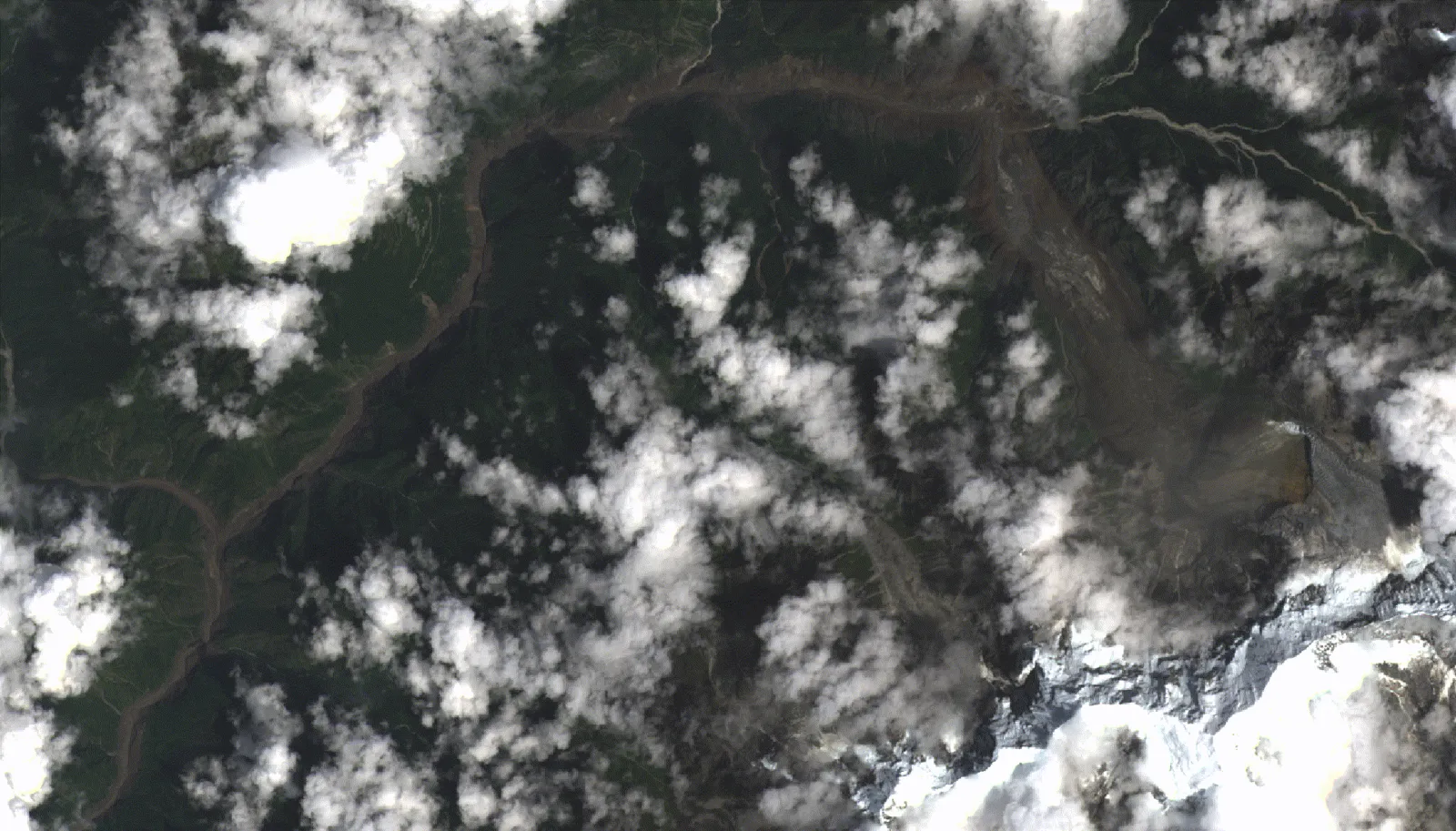
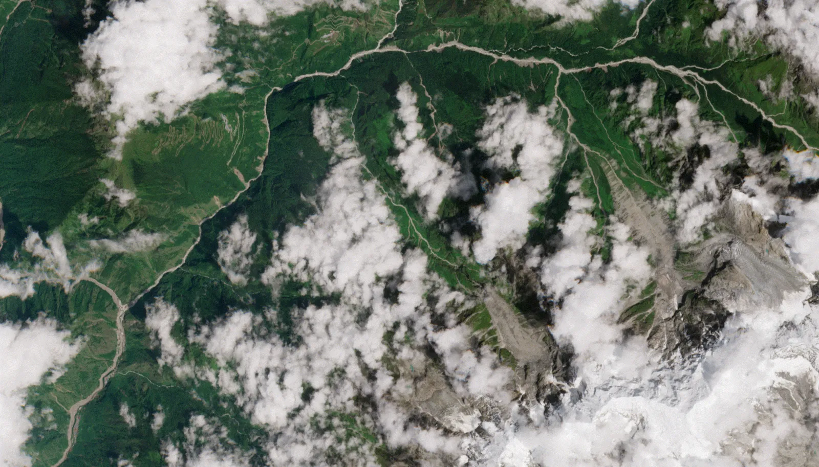 24 Aug · before
26 Aug · after
24 Aug · before
26 Aug · after
We got there. Then we handed the job to people who were already doing it.
The vehicle loaded in Siliguri on 31 August and crossed after several days of delays. What we found on the other side was that the useful thing was not to run our own distribution in a valley we do not know, but to put our people, our vehicle and our money behind an organisation that was already working in it.
Our own footage, Trishuli, Nuwakot and the Rasuwa border, published 10 September 2026. Shot on a phone by the team, captions theirs. Humrahi Foundation. Also on Instagram →
What is in it, and what is not
The road on arrival, the relief vehicle loaded with quilts and bottled water, boxed medicines, and the handovers at holding sites at Trishuli, Nuwakot and Badravati, at the Rasuwa border. The people in it are KarmaYog's team and ours together; the ones receiving are families from the affected belt.
What is not in it is a number. We did not keep a register of households, and we are not going to borrow someone else's count and publish it as our reach. What we did was arrange the vehicle, run the logistics, and work the on-ground operation alongside KarmaYog — who secured the supplies and had already found where relief was not reaching — which is worth saying plainly rather than dressing up.
We also did not go up to the breach itself in upper Rasuwa. That is still an active rescue site with a landslide-dammed lake above it, and untrained hands arriving there are a burden on the responders.
Closed
Cash was the first ask, spent on the Nepali side: cooking gas first, then the tools and stock that get a living started again. The appeal closed on 2 October 2026 having raised ₹23,150 from 35 gifts.
Support our current work →Send rebuilding supplies
The need in Nepal has moved from getting a family through the week to putting a house and the things in it back. The whole list is three items:
- Solar lights
- Building materials
- Household items
Please do not send food or clothes for Nepal. There is enough of both, and surplus we could not hand to a family without apologising for it becomes our disposal problem rather than their relief. Solar lights because they work with no grid behind them. New, or clean and genuinely usable. Bring it to Siliguri and it travels on our own vehicle; call to arrange a drop-off or a pickup.
Come with us
Our own people went with the first vehicle and worked the holding sites. We are not taking untrained volunteers into the rescue zone in upper Rasuwa, where a landslide-dammed lake still sits above the valley. If you want to be on a later run, or to help at the loading point in Siliguri, tell us what you can do and we will answer honestly.
Call Ankit on +91 77976 63663 →What we are not claiming. We did not lead this. KarmaYog Foundation secured the relief supplies through DHL and had already found where relief was not reaching; what we brought was a vehicle, the logistics, and people running the ground operation together with them, and nothing beyond this response is agreed with them, so we are not describing it as a standing arrangement, and we will not put a families-reached figure on this page while the register belongs to somebody else. The fuller field report, with what the money bought and whatever did not go to plan, follows in the same shape as our Assam one.
This appeal is closed
It ran from 27 August to 2 October 2026 and raised ₹23,150 from 35 gifts, spent as described in the field report above. The Seva Stack project for this appeal is closing, and the donation chips and forms that ran here have been taken down. This page stays up as the record of what was done, with its sources.
Want to support our current work instead? Use the general donate page.
Three phases. One of them is done, and we are not pretending about the other two.
Relief is the part everyone photographs, and it is over. What decides whether a family is still standing in a year is the slow work that comes after it, so this is the shape of the whole thing rather than the shape of the week we were there. Phases two and three have not started.
Relief, and listening
The vehicle left Siliguri on 31 August 2026 with ration, blankets, medicines and cooking gear. The full load was never customs-cleared: it crossed twice under the personal-goods allowance that lets an individual carry about ₹25,000 of goods across, and what could not cross stayed behind and later went to our Bihar relief work instead. What did cross was handed over at Trishuli, Nuwakot and Badravati, at the Rasuwa border. KarmaYog Foundation secured the relief supplies, through DHL, and had already found where relief was not reaching; we arranged the vehicle and ran the logistics and the on-ground operation. We also went into Rasuwa itself, but the roads would not let us take relief any further. What it was not: a walk up to the breach in upper Rasuwa, which is still an active rescue site with a landslide-dammed lake above it. The footage is above; the written field report follows.
The other half of those days was sitting with people and asking what they had actually lost. That is what turned into phase two.
See how we reported Assam →A profile for each household
Relief keeps a family alive for a fortnight. What decides the next year is whether anyone knows enough about them to be useful. So the next phase is slow and unphotogenic: sitting with a household and writing down who is in it — what each working-age member can actually do and has done before, what they would want to do next, which children were in school and whether they still are, and what the older or unwell members need in the way of care. And the question underneath all of it: does this family want to stay, and if not, is that somewhere else in Nepal, or would they consider India too.
None of this has begun. There is no dataset, no count, and no family surveyed. When it starts it will be our own people doing the asking, with KarmaYog alongside, and it will be done under the rules set out below rather than as a clipboard exercise.
How we will handle that data →Turning a profile into a living
A profile is worth nothing sitting with us. Phase three is carrying it — only with the family's agreement, and only the parts they agree to — to people who can act on it: employers and industry bodies who are hiring for the skills that are actually in that household, and other organisations who cover what we cannot. We are a small foundation and most of what a displaced family needs is outside what we do, so a large part of this phase is honestly just introductions.
The intended output is a package per family rather than a grant: work, schooling for the children, and whatever support they are already entitled to. We have not built one yet, and we will not describe one as though we had.
Hiring, or working in this? Talk to us →The rules phase two runs under, written before it starts
A family profile of the kind above is about as sensitive as a record gets: health, children, schooling, income, and whether a household is thinking about leaving the country. Publishing the intention without publishing the limits would be the easy version, so here are the limits. They apply from the first household onward, and we would rather be held to them in public.
- Asked, not collected. Nobody is surveyed without being told first what the questions are for, who will see the answers and what happens if they say no. Saying no changes nothing about what relief they receive.
- Children's details only with the guardian's consent, given in front of us, and never a child's record on its own.
- Nothing moves without the family's say-so, each time. A profile is not shared with an employer, an industry body or another organisation unless that family agrees to that sharing, and they can agree to part of it and refuse the rest.
- Relocation is a question, not a plan. Asking whether a household would consider moving — within Nepal, or to India — is how we know what to look for. It is not a scheme, we are not recruiting labour, and no answer to that question is passed to anyone who is hiring unless the family has asked us to.
- Withdrawal works backwards. A family can have their profile deleted at any point, including after it has been shared, and we will tell whoever we shared it with.
- No names on this website. Anything we publish from phase two is aggregate. Individual profiles are not case studies and will not be used as fundraising material.
Humrahi Foundation holds this data and is answerable for it, with KarmaYog Foundation assisting on the ground. Our privacy policy covers how we handle personal data generally; if you think any of the above is not good enough, that is worth telling us before it starts rather than after. — +91 97333 03333
Where things stand, 4 September 2026
Published 27 August, figures restated 12 September against the 4 September count. Every figure below carries the source that published it and when.
The count has roughly tripled since this page opened. On 27 August the same event was being reported at anywhere between 165 and 389 dead by six sources inside one day; the figures now attributed to Nepali authorities and UN agencies, as of 4 September, are an order of magnitude worse. We have restated the headline tiles rather than quietly editing them: the 27 August spread is still in the revision log, row by row, so you can see what was said when.
A second surge is still possible. Nepali authorities have warned that a lake formed behind landslide debris upstream is rising, and have told residents and rescue workers along the Bhote Koshi to stay off the banks. That warning is why we did not take volunteers up to the breach, and why our people worked from the holding sites downstream rather than in the rescue zone itself. The primary-source panels and the full revision log are in the live tracker; the full source list is at the foot of this page.
Straight answers
Is Humrahi still collecting for Nepal?
Why should I trust Humrahi Foundation with Nepal flood relief?
Is Humrahi sending a team to Nepal?
Can I send clothes or food for Nepal?
What happened in Nepal on 26 August 2026?
How many people have died in the Nepal floods?
Where can researchers get the underlying data for this event?
What happens after relief? You mention a second phase.
One door opened. We could use more.
In Nepal the door was KarmaYog Foundation: they had already found where relief was not reaching, and we partnered with them at Trishuli, Nuwakot and the Rasuwa border, arriving with a vehicle and no local standing of our own. That is one organisation in one response, against about 10,000 households that need relief. If you run, work with, or can vouch for another group operating in Rasuwa, Nuwakot or Dhading, or you are a Nepali diaspora group in Siliguri, Darjeeling or Kalimpong already coordinating something, please get in touch. What we are looking for is what Nine Story Foundation gave us in Assam and what KarmaYog gave us here: people who already know which households need what, and who can account for what they hand out.
The same goes for companies, schools and colleges that want to run a collection for this. Talk to us before you start, so what you raise lands somewhere real.
The rivers that did this drain south as well as down. As of 11 September 2026 the Bihar Disaster Management Department has 46.88 lakh people across 15 districts under flood, and its bulletin names rainfall in Nepal's catchment as one of the two causes. We are opening a response there and are looking for the same thing — someone already on the ground. The Bihar page says what we have and have not done →
Or call +91 77977 07700. We answer.
Background, sources and methods
Everything below was on this page as eight open sections. It is all still here, word for word, folded up so that a donor is not made to scroll past a research paper, and open to anyone who wants it. Journalists and researchers: the primary sources and endpoints are in data and methods.
An hour of water, and no rain to explain itHow an ice avalanche 20 km away became a wall of water, and what is still uncertain.
At 08:37 Nepal time on 26 August 2026 (02:52 UTC), instruments recorded a signal in the high Langtang. The United States Geological Survey catalogued it at magnitude 5.2, at 28.271°N 85.515°E, at a depth of zero kilometres — and, critically, classified the event type as “landslide” rather than “earthquake”. That classification is visible in the live panel above and is the primary-source answer to a discrepancy that runs through the press coverage, where the same event is variously reported as M4.4 and M5.2. A zero-depth landslide solution is what a large mass of ice and rock striking a valley floor looks like on a seismometer; it is not a tectonic rupture.
The mass came off Langtang Lirung (7,245 m), whose northern face lies inside Nepal. A geologist at the University of Calgary identified in satellite imagery a section of glacier roughly 2,000 feet wide that detached and fell close to 4,000 feet. Imagery from Planet Labs placed the avalanche around 20 km north-east of Rasuwagadhi.
Why an avalanche became a flood
The debris landed in the Lhende Khola, a tributary along the Nepal–China border, and dammed it. Water and sediment ponded behind that dam — a landslide dam, not a pre-existing glacial lake — and then the dam failed. Preliminary imagery shared by Chinese authorities and circulated by ICIMOD put the blockage about 20 km upstream of the Miteri Bridge.
What came down was therefore not clear water. Binod Parajuli, who heads the Flood Forecasting Division at Nepal's Department of Hydrology and Meteorology, put the point directly: an icefall and landslide are visible in the imagery, an ice-and-debris lake formed and then burst, and, in his assessment, clear water alone would not have produced destruction on this scale. The sediment load is what turned a surge into something that removed settlements rather than flooding them.
How fast it travelled
Locally there had been almost no rain, so nothing about the morning warned anyone downstream. The river rose at Rasuwagadhi with what observers described as extraordinary speed, took Timure and Syabrubesi, then ran into the Trishuli. Gauges downstream registered a rise of nine metres at Galchhi and seven metres at Malekhu within thirty minutes. Alerts followed down the Trishuli into Nuwakot, Dhading, Gorkha and Chitwan.
What is still uncertain
- Whether a glacial lake was also involved. The working reading is an ice-and-rock avalanche and a debris dam. Rijan Bhakta Kayastha, a climate researcher at Kathmandu University, has said it could take several days to determine whether a glacial lake burst as well.
- Whether the seismic event triggered the avalanche or recorded it. Kayastha has noted the timing is suggestive but the causal direction is not established. The zero-depth “landslide” classification argues that the catalogue entry is the avalanche rather than a separate trigger.
- The full sequence. Sarthak Shrestha, a remote-sensing associate at ICIMOD, has put the time needed to establish the complete picture at another one to two weeks. Cloud cover has hampered satellite monitoring throughout.
- Whether the Lhende has fully cleared. Home Minister Sudan Gurung confirmed on 26 August that it had not.
We are stating these as open questions because they are open. Anyone presenting the trigger sequence as settled two days in is ahead of the evidence.
There is a second lake, and it is fillingA second lake is filling behind landslide debris upstream.
The most important fact on this page is not in the casualty figures. China's Ministry of Water Resources has reported a large barrier lake formed near the confluence of the Chotchen and Purupe Tsangpo rivers in Tibet. By the morning of 27 August roughly two million cubic metres had accumulated behind it, with Chinese projections indicating a further three million cubic metres could enter within three days.
If that barrier fails the way the first one did, a second surge runs down the same valley, over rescue teams, over the survivors who have come back to look for people, and over a river corridor whose bridges are already gone. Nepali authorities have warned residents and rescue workers along the Bhote Koshi to stay off the banks. Chinese authorities have established continuous monitoring and run breach simulations. Cloud cover is limiting satellite observation of the site.
On 27 August the NDRRMA went further and warned that the Lhende Khola itself, the tributary whose blockage caused the first surge, has seen another build-up of water behind fresh blockages, and flagged renewed flood risk on the same channel. It repeated the instruction to stay off the banks. That is two separate impoundments now being watched on the same river system, one in Tibet and one at the original failure site.
This is the single reason Humrahi is not sending volunteers, and we would say the same to anyone else considering it: the valley is not safe to enter, and untrained people in it are a liability to the responders.
What the surge destroyedBridges, road, hydropower and the border, counted.
Figures below are as reported to 27 August 2026 and will be revised. Deaths have been confirmed across seven districts (Rasuwa, Nuwakot, Dhading, Chitwan, Tanahun, Gorkha and Nawalparasi East), which is a wider spread than the two districts the initial reporting named.
Hydropower on the Bhotekoshi–Trishuli cascade
The corridor carries a chain of run-of-river plants, which is why a single surge took roughly 430 MW off Nepal's grid at once. One project was swept away outright.
| Project | River | Status reported |
|---|---|---|
| Rasuwagadhi (111 MW) | Bhotekoshi | Damaged, generation halted |
| Chilime | Chilime / Bhotekoshi | Damaged |
| Trishuli 3A | Trishuli | Damaged, generation halted |
| Trishuli 3B | Trishuli | Damaged |
| Trishuli | Trishuli | Damaged |
| Devighat | Trishuli | Damaged |
Sources: Nepal Ministry of Energy figures reported 26–27 August 2026; The Kathmandu Post, 26 August 2026. Reports of the number of affected projects range from six to “more than ten” along the two rivers; the six above are the ones named consistently.
The border
The Rasuwagadhi customs post was destroyed and the Gyirong Port on the Chinese side was reported completely destroyed. This is not only a local loss: Rasuwagadhi–Gyirong is one of the two main overland trade gateways between Nepal and China, and the corridor has now been severed twice in fourteen months.
This valley has now done this twice in fourteen monthsThe same valley did this in July 2025. Why it keeps happening.
On 8 July 2025, a flood came down the same stretch of the Bhotekoshi, swept away the Miteri Bridge linking Nepal and China, and damaged the Rasuwagadhi dry port. At least nine people were killed and nineteen went missing. Nepal's Department of Hydrology and Meteorology, working from Sentinel satellite imagery, attributed that event to a glacial lake outburst in the Lhende river near the border, a different mechanism from the 2026 avalanche-and-debris-dam sequence, in the same few kilometres of river.
The two events together describe the problem. The Bhotekoshi corridor sits directly beneath retreating Himalayan glaciers, and it carries a border crossing, a hydropower cascade and a string of settlements in a narrow gorge with nowhere to go sideways.
The wider glacial-lake picture
Research by ICIMOD with UNDP has catalogued 3,624 glacial lakes across the Nepal, India and Tibet portions of the Koshi, Gandaki and Karnali basins. Of these, 47 are classified as potentially dangerous — and 21 of those sit in Nepal. Those are the lakes. The 2026 event was not one of them: it began as an ice-and-rock avalanche, and the lake that killed people did not exist until the avalanche created it, minutes earlier.
That is the part worth carrying away. Hazard mapping built around known, catalogued lakes does not capture a dam that forms and fails inside an hour. As Kayastha has put it, rising temperatures increase the likelihood of glaciers melting and of ice and rock breaking apart, and an avalanche can manufacture a reservoir upstream of a populated valley with no warning at all. Nepal's early-warning systems on this corridor were built for a different failure mode.
Who is doing whatMilitaries, governments and donors, and the gap afterwards that this appeal is for.
Nepal. The Nepal Army, the Armed Police Force and Nepal Police were mobilised on the day. The NDRRMA had recorded 113 people rescued from Timure, Dhunche, Syabrubesi, Uttargaya and Bidur by 27 August: 88 Nepali citizens, 11 Indian, 8 Chinese, 4 Korean and 2 American. The Home Ministry has deployed twelve coordinating teams. NDRRMA's spokesperson is Shanti Mahat; the Home Minister is Sudan Gurung.
International. India flew in 50 tonnes of relief on 26 August, and Prime Minister Modi spoke with Prime Minister Balen Shah. The United States committed $500,000 and a disaster response advisor; the United Kingdom pledged £5 million; the Red Cross released $1.4 million; the UN Secretary-General activated support. On the Tibetan side, roughly 800 emergency workers and 150 vehicles were deployed.
Where the gap is. Rescue is being handled by militaries and national agencies, which is correct, because it needs helicopters and engineers rather than NGOs. The gap opens afterwards: households in a gorge whose bridges, road, market, customs employment and hydropower jobs are gone at once, and who are not going to be reached by an airlift. That is the phase small organisations can actually serve, and it is what this appeal was raised for.
What the primary sources say, right nowTwo open government APIs, queried live, plus the full revision log of every figure.
The two panels below query open government APIs from your browser each time this page loads, so nothing is cached or retyped by us. The table underneath is the opposite: a hand-kept log of every headline figure and every time it moved, so a researcher can see the revision history rather than only the latest number. If you need the raw endpoints, they are in data & methods.
Seismic record of the collapse
Live · USGS earthquake catalogue
Loading the USGS catalogue…
Querying earthquake.usgs.gov
Nepal's official incident record
Live · NDRRMA BIPAD portal
Loading the NDRRMA incident feed…
Querying bipadportal.gov.np
Revision log of the headline figures
Every row is a figure as a named source published it, at the time it published it. Rows are added, never overwritten, so a superseded number stays visible and the revision history is auditable.
| When (NPT) | Figure | Value | Source |
|---|---|---|---|
| 26 Aug, morning | Dead, Nepal | 8 | Al Jazeera / early wire reports |
| 26 Aug, midday | Dead, Nepal | 95 | Officials via NPR “at least 98” incl. China |
| 26 Aug | Dead, China (Tibet) | 3 | CCTV via AP 558 missing in Gyirong County |
| 27 Aug | Dead, Nepal | 165 | UPI |
| 27 Aug | Dead, Nepal | 289 | NDRRMA, via The Kathmandu Post |
| 27 Aug | Dead, Nepal | 353 | Nepal Police, via wire agencies |
| 27 Aug | Dead, Nepal | 359 | BBC News |
| 27 Aug | Missing, Nepal | 826 | Nepal Police incl. 578 tourists / cross-border travellers |
| 27 Aug | Missing, Nepal | 910 | BBC News |
| 27 Aug | Injured | 73 | NDRRMA |
| 27 Aug | Rescued | 113 | NDRRMA 88 Nepali, 11 Indian, 8 Chinese, 4 Korean, 2 American |
| 27 Aug, evening | Dead, Nepal | 380 | Nepal Police PHQ, via TIME “over 380” |
| 27 Aug, evening | Dead, Nepal | 389 | Nepal News |
| 27 Aug, evening | Missing, Nepal | 900 | NDRRMA, via TIME “at least 900” |
| 27 Aug | Missing tourists | 668 | Nepal News from 34 countries; 127 of them domestic Nepali tourists per BBC News Nepali |
| 27 Aug | Missing, Indian nationals | 285 | Ministry of External Affairs, India “not been able to establish contact” |
| 27 Aug | Missing, security & border staff | 104 | The Himalayan Times 28 police, 44 army, 13 APF, 15 customs, 4 immigration |
| 27 Aug | Bodies recovered | 258 | The Himalayan Times |
| 27 Aug | Rescued by helicopter | 351 | Nepal Army, via The Himalayan Times |
| 27 Aug | Barrier lake, Tibet | 2M m³ | China Ministry of Water Resources +3M m³ projected within three days |
| 4 Sep | Dead, Nepal | 1,200 | Nepali authorities & UN agencies, via Direct Relief “at least 1,200”, still being confirmed |
| 4 Sep | Missing, Nepal & Tibet | 5,000 | Nepali authorities & UN agencies, via Direct Relief “more than 5,000” |
| 4 Sep | Households needing relief | 10,000 | UN OCHA, via Direct Relief |
Why four different death tolls for the same day. Nepal Police count bodies recovered; NDRRMA counts what districts have formally filed; news organisations count what they can confirm from either. A large share of the missing are trekkers and cross-border travellers with no local next-of-kin to report them, which is why the missing figure moves independently of the dead. None of these is wrong. They are measuring different things. Treat the spread as the honest uncertainty, not as one source being unreliable.
For researchers and journalistsEndpoints, district and hazard IDs, our figure-handling method and reuse terms.
If you are working on this event, take the primary sources rather than this page. Everything below is open, needs no key, and is what the live tracker above queries.
Query these directly
- USGS earthquake catalogue (FDSNWS) — the seismic record of the collapse, including the
type: landslideclassification. CORS-open, no key.earthquake.usgs.gov/fdsnws/event/1/query?format=geojson&starttime=2026-08-20&minlatitude=27.6&maxlatitude=29.4&minlongitude=84.6&maxlongitude=86.4 - NDRRMA BIPAD portal — Nepal's official incident register, with per-incident loss breakdowns (deaths, missing, injured, families, infrastructure). CORS-open, no key. District IDs used here: Rasuwa 23, Nuwakot 25, Dhading 26, Gorkha 44, Chitwan 35, Nawalparasi East 481. Hazard IDs: Flood 11, Landslide 17, GLOF 26, Avalanche 3, Inundation 28.
bipadportal.gov.np/api/v1/incident/?district=23&incident_on__gt=2026-08-25&expand=loss,hazard
Caveat, and it matters: as of 27 August this register contains no Bhotekoshi records. It is filled in by local authorities, and Rasuwa cannot file. Do not treat its totals as a toll. - ReliefWeb — situation reports from responding agencies. The v2 API requires a registered
appname, so this page does not query it. - ICIMOD — the remote-sensing analysis of the avalanche and the glacial-lake inventories. Department of Hydrology and Meteorology (DHM), Nepal — river gauges and the flood-forecasting division's assessments.
- Copernicus EMS and UNOSAT — for post-event satellite damage mapping, if activated. Planet Labs imagery is what the published avalanche identification rests on.
How we handle the figures on this page
- Every figure carries the source that published it and the date it was published. Where sources conflict, all values are shown — see the revision log in the live tracker.
- Superseded numbers are added to the log, never overwritten, so the revision history stays auditable.
- The two live panels query the APIs from your browser on each page load. Nothing is cached or transcribed by us, and each panel stamps the time it was queried.
- We do not publish a single “official” toll. Nepal Police, NDRRMA and news organisations are measuring different things; the spread between them is the honest uncertainty.
- Corrections: email a@myhumrahi.org. If you can show a figure here is wrong, we will change it and log the change.
Reusing this
The compiled figures, the revision log and the source list on this page may be reused freely with attribution to Humrahi Foundation and a link back. The underlying data belongs to the agencies listed above and carries their terms. The two Assam photographs are ours; the page carries no third-party photography, deliberately.
Where these figures come fromEvery figure on this page, with the source that published it.
Nepal's official counter is the National Disaster Risk Reduction and Management Authority (NDRRMA). Where a figure on this page comes from a news organisation rather than the NDRRMA, the tile says so. Because the counts are still moving, treat every figure here as a snapshot taken on 27 August 2026 — the revision log shows how each one moved.
- CNN — rolling live coverage of the Nepal flash floods, from 26 August 2026. Toll, missing counts, second-surge warning.
- Direct Relief — Nepal floods 2026 emergency response, figures as of 4 September 2026. The source of this page's restated headline count: at least 1,200 dead, more than 5,000 missing across Nepal and Tibet, and about 10,000 households needing immediate relief (UN OCHA), attributed to Nepali authorities and UN agencies and still being confirmed.
- UPI — “Nepal flash flood death toll climbs to 165 with hundreds still missing”, 27 August 2026.
- Wikipedia — 2026 Nepal floods. Consolidated timeline, casualty table by nationality, and infrastructure damage, each entry sourced to BBC, AP, Reuters, The Kathmandu Post and India Today.
- The Kathmandu Post — “Flash flood hits Rasuwa, damages hydropower projects and markets”, 26 August 2026. Hydropower and market damage; the July 2025 precedent.
- NPR — avalanche-triggered flash floods in Nepal and China, 26 August 2026.
- Al Jazeera — photographs from the Nepal Himalaya avalanche floods, 26 August 2026.
- CARE — statement on the Bhote Koshi flash flood response, August 2026. NDRRMA rescue figures and relief coordination.
- UNICEF — deadly flash flooding hits Nepal, August 2026.
- USGS earthquake catalogue — the 26 August 2026 event at 28.271°N 85.515°E, M5.2, depth 0 km, event type “landslide”. Queried live by the tracker on this page.
- NDRRMA BIPAD portal — Nepal's official disaster incident register. Queried live by the tracker; holds no Bhotekoshi records as of 27 August 2026.
- The Kathmandu Post — “Bhotekoshi flood: what happened in Nepal's Himalayas and what comes next”, 27 August 2026. Langtang Lirung, the downstream gauge rises, the Tibetan barrier lake, and the seven districts with confirmed deaths.
- The Kathmandu Post — “Ice avalanche, debris lake may have triggered Bhotekoshi flood”, 26 August 2026. Binod Parajuli (DHM), Rijan Bhakta Kayastha (Kathmandu University), the 20 km blockage upstream of the Miteri Bridge.
- The Kathmandu Post — “Scientists suspect ice avalanche triggered Bhotekoshi flood”, 26 August 2026. ICIMOD's reading and Sarthak Shrestha's assessment.
- Scientific American — “Wall of floodwater sweeps away villages in Nepal”, August 2026. The University of Calgary satellite identification of the detached glacier section.
- ICIMOD with UNDP — glacial-lake inventory for the Koshi, Gandaki and Karnali basins: 3,624 lakes catalogued, 47 potentially dangerous, 21 of them in Nepal.
- Nepal Department of Hydrology and Meteorology — Sentinel-based attribution of the 8 July 2025 Bhotekoshi flood to a glacial lake outburst in the Lhende.
- For Humrahi's own Assam figures cited in the record section above, see the sources on our Assam flood relief page.